
The Best Drones for Surveying: Faster, Safer & Better Surveys
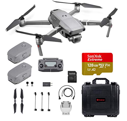
DJI Mavic 2 Pro
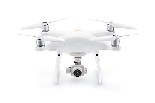
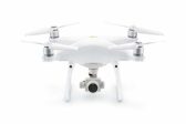
DJI Phantom 4 Pro V2
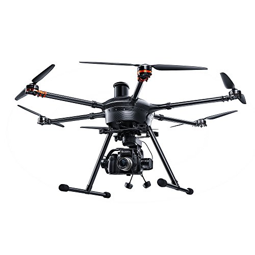
Yuneec YUNH920US
As we all know, you can’t do the best job if you don’t have the tools.
Surveying or calculating distances from the ground is a hard job that needs a lot of repetition and readjustment. Thankfully, with some of these incredible surveying drones, you won’t need to measure multiple times in the field, but simply use photos at a cozy office.
The advantages of surveying with the drone can’t be overstated. Drones meant for this job have all sorts of tools to ensure that your measurements are to the point. And, you will always know what you are looking at.
Additionally, you will be taking high-quality photos that will show all markers clearly from a significant distance. Even by measuring a small portion of the area, you can use GPS and visual data to extrapolate the whole thing.
In general, drones not only cut the workload of surveying in half but also allow you to do half of the remaining work from the office and not in the field. This will be sure to save you on those freezing cold or burning hot days!
While the very pinnacle of surveying drones can garner a very high price, this is not necessarily the case for all drones that can be used.
If you tend to survey smaller plots or mostly flat areas, you will be able to help yourself to a consumer model that will suit your needs. They will have virtually everything you need.
The best drones for surveying will always have two features that stand above the rest: GPS precision, and a powerful camera. The ability of the drone to stay in a specific coordinate and gather data is what makes your job easier.
Additionally, you will be looking for a drone with the good flight time. An experienced surveyor will be able to mark the elevation point in a matter of seconds, but no one needs the added stress of a dying drone whilst completing the task.
We’ll take a look at the best surveying drones in a moment. But first, we wanted to say: we have a separate guide on the best drones for roof inspections — if that’s why you were here.
Assuming you’re here for other surveying purposes, let’s continue!
The Best Surveying Drones
We may receive compensation on qualifying purchases via our links. This does not change how we review items. For more information, please read our affiliate disclosure.
If you’re looking for top-of-the-range quality for surveying whilst remaining inside business budgets, this might be your drone.
- Flight Time: 30 minutes
- Range: 7 kilometers
- Camera: 4K resolution at 30 fps; 20 MP stills
- Weight: 1.64 pounds
- Gimbal: 3 Axis
Most surveyors know that there are jobs so remote that some trekking will be necessary. Thinking about the equipment you will carry here is essential, because you don’t want to burden yourself.
Here is where the DJI Mavic 2 Pro comes in, as it is one of the most portable professional drones on the market today. Unlike its larger cousin, the Phantom 4 Pro, it can fold its wings and fit easily in a backpack.
This drone is slightly harder to fly manually than the ‘fixed-wing’ models, but as a surveyor, you will be using the GPS waypoint system much more often. With this system, you can order the drone to assume the position you want.
Finally, while few surveyors will ever want to test this feature, the Mavic 2 Pro works at -10°C (14°F), making it possible to work in any weather — well, almost!
+ Pros
This is a great quality bit of kit. DJI truly know what they’re doing when it comes to drones.
- Flight Time: ~30 minutes
- Charge Time: ~360 minutes
- Range: 7000m / 4.3mi
- Remote Controller: WiFi 2.4GHz with 5.4Ghz video transmission (included in the set)
- Camera: 24mm / 1inch CMOS / f/2.8 – f/11 / 20MP / 3-axis gimbal
- Live Video Transmission Range: 7000m / 4.3mi
- Weight: 1375g / 3.03lbs
- Working Temperature: 0°C to ~ 40°C
- Rated for indoor and outdoor use
DJI is the world’s forerunner when it comes to both consumer and professional drones. The Phantom 4 Pro V2 threads the line between being easy to fly as a consumer drone and a powerful tool for many types of jobs.
When surveying, you will be using the drone’s excellent GPS functions, as well as its amazing 20MP 1-inch camera. With just a few markers on the ground, this drone can do the job for you.
GPS is the key here because you can chart an exact location where you want your drone to shoot. Here, you will also know the elevation of the drone and the angle of the shot.
Even without any markers on the ground, you will have your three points to do the math. And if you have the corners of the land you are surveying, that math becomes easy.
And, unlike surveying on the ground, adding multiple data points is quick and easy. You don’t need to trek through the mud for miles to make dozens of points. You simply move the drone to the next location and take new shots.
With the 30-minute battery time, you will be able to survey most locations in one sitting. For others, you return your drone, plug it in, and take some time to review the photos from a comfortable position.
Alternatively, if you want to finish your day and return the base as soon as possible, you can always carry additional batteries. These are simple to change and would take as much as it takes for you to download the photos.
+ Pros
- Cons
This is a pretty expensive hexacopter drone, but boy does it offer up some real quality for your work.
- Flight Time: ~22 minutes
- Charge Time: ~3×180 minutes
- Range: 915m / 3000ft
- Remote Controller: WiFi 2.4GHz with 5.8Ghz video transmission (included in the set)
- Camera: 3rd party
- Live Video Transmission Range: 760m / 2500ft
- Weight: 890g / 1.96lbs
- Working Temperature: Depending on the camera
- Rated for indoor and outdoor use
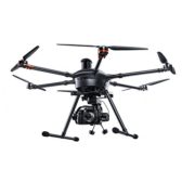
Those who need specific imaging and precise measurements of multiple angles and heights will love this drone.
For other drone manufacturers, the biggest problem is installing the camera to get a perfect, crisp picture that will show everything. Yuneec circumvents this issue by not making the camera at all.
Rather, you will be placing your own DSLR camera to the gimbal, with whichever lenses you need, to get the ideal image for later measurements. The proposed Panasonic GH4 may work best, but almost all DSLR cameras will be compatible as well.
The drone itself is focused on stable flight and precise GPS signals. It will also send a video feed to your smartphone from the camera LCD screen.
Finally, the body of the drone is made from carbon fiber, making this hexacopter capable of lifting heavier lenses, allowing it more versatility.
+ Pros
- Cons
If you’re looking for an affordable route into exploring with drone surveying, this might be the option for you.
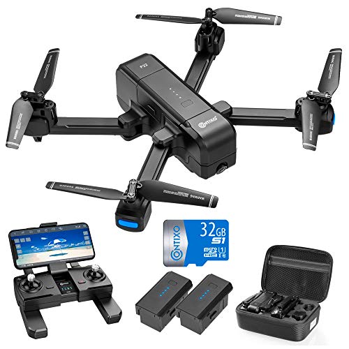
- Flight Time: ~15 minutes
- Charge Time: ~90 minutes
- Range: 550m / 1800ft
- Remote Controller: WiFi 2.4GHz (included in the set)
- Camera: FPV 1080p Camera with 8MP
- Live Video Transmission Range: 550m / 1800ft
- Weight: 204g / 0.45lbs
- Working Temperature: 0°C to ~ 40°C
- Rated for indoor and outdoor use
New surveyors, or those new to drone surveying, might not want to spend too much money to test the concept out. Professional drones can cost thousands of dollars, after all.
The solution here is the Contixo F22 Plus, which has all of the GPS features that will help your math and a camera good enough to see stationed markers from a large distance.
The F22 connects to your smartphone and gives you a clear transmission of what your drone is seeing. Here you can snap images and look them over, helping yourself plan your measurements.
The wide-angle camera will help you make measurements of large areas without distortion. Combining this with the ability to go up to 1000ft for that view can make your job much easier.
While this drone won’t be able to do your surveying job for you, it will help you avoid mud and shrub, by giving you a clear view of what you want to see without the need of you trekking there yourself.
Although this provides good value, you are sacrificing a good amount of flight time in exchange for the lower price.
+ Pros
- Cons
One of the top of the range drones that money can buy. Absolutely perfect for professional projects like surveying.
- Flight Time: ~25 to ~45 minutes (depending on the payload)
- Charge Time: ~6×180 minutes
- Range: 5000m / 3.1mi
- Remote Controller: WiFi 2.4GHz with 5.4Ghz video transmission (included in the set)
- Camera: FPV 2K Camera with 12MP
- Live Video Transmission Range: 5000m / 3.1mi
- Weight: 10Kg / 22lbs
- Working Temperature: Depending on the camera
- Rated for outdoor use
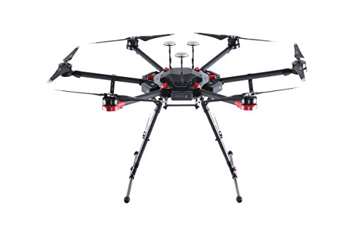
The worst of jobs always need the best of tools, and that is the case with surveying. The Matrice 600 Pro will certainly become the industry standard when it comes to professional drones.
The drone itself is all about reliability, stability, and versatility. The six blades offer ideal flight in most conditions, and the redundancy system is valuable to keep your drone in flight in the case that some of the modules get damaged.
This security is essential, as the M600 Pro will use your professional camera equipment. The drone will ensure that that equipment doesn’t get damaged in any way.
The gimbals will allow all types of cameras to be installed, including those that can measure levels and coordinates.
By using the DJI Fly app, you will be able to control the drone through a tablet or smartphone, accessing all of the information you need directly. With smart AI features, this drone can do most of your work for you.
With the six batteries on the drone itself and the one dedicated to the gimbal and the camera, you can expect over 25 minutes of flight even with the heaviest of equipment.
The drone can lift to 35lbs, and can fly longer with lighter equipment. With a good surveyor camera, this can well past the 30-minute mark.
Finally, the device itself is very easy to fly.
+ Pros
- Cons
A Quick Buyer’s Guide to Surveying Drones
A surveyor’s job is a strange one. It combines some of the intellectual capacity needed for a STEM job with the labor required when you work in the field.
For a long time now, surveyors have made tools and markers to help them do their job faster and with fewer calculations. But, until now, they weren’t able to fly.
When looking for the best drone for surveying purposes, you will be looking for tools to do your work with less sweat on your brow. Less math and less walking means the job gets done faster, pushing the hourly wage up quite a bit — or allowing you to get more work done in the same time frame.
Additionally, with a drone, you don’t need as big of a team when working on the ground. Only a couple of people (maybe even a lone surveyor) and a drone can finish the job in a short amount of time. This allows for more contracts and more flexibility.
Most experienced surveyors will easily recognize the features they need to film the whole job site in minutes. Those who are not yet familiar with drone technology will only need to do a little bit of research.
If you know the demands of your average job, you will recognize the type of drone you need. Those that measure small but difficult plots will need better cameras with not that much range. Others will prefer longer ranges to reduce their daily step count.
How Can the Drones Be Used for Surveying?
One of the first things a surveyor learns is how to think in 3D. No land is perfectly flat, and even plains and flatlands have slight altitude differences that need to be accounted for.
With a camera drone, you can have a fixed data point in the air that knows its coordinates, altitude, and can capture on camera all of the other data points.
Hypothetically, if you have a good enough camera, you can even throw a meter on the ground and use the drone to calculate vast areas.
Additionally, drones are connected to smartphones, tablets, and computers directly. This can let the AI do most of the calculations for you. Data points can be quickly extrapolated to figure out the level and the size of the land you are surveying.
Finally, having this data stored will allow you to do recalculations and adjustments from your office without always needing to go back to the field. Aerial photography can include multiple markers from the exact GPS coordinates.
Once you have all the data, the rest is left to good old Pythagoras, who would have probably loved to have a drone, as he often hypothesized how it would be to have a bird’s eye view.
What Are The Advantages Of Using A Drone?
In the shortest of terms: not walking.
When doing calculations from the ground, you need to select a position, figure out your relative coordinates, fix the marker, and keep going. Depending on the size of the land, this can take several days.
With a drone, you only need a couple of markers, and they don’t need to be that far apart. As you fly the drone, you will get the exact GPS coordinated to your controller. You leave the drone standing, snap some photos, and glide to the side.
With a drone, it is possible to make hundreds of data points by the time the battery runs out. This will include pictures from different altitudes and even laser calculated distance.
What to Look for in a Surveying Drone
The primary feature for any surveyor drone will be the stability. You will want your drone to stay in exact coordinates until you tell it to move.
Thankfully, drones with GPS and adequate motors will always be stable when it comes to position.
Next, you will want to have the stability and level of the camera. A movable axis and a gimbal are good features when it comes to exact measurements using only drone imagery.
Finally, the quality of the camera should be taken into consideration. This might not be vital for those who survey homogenous territories, but in most cases, it will be a huge benefit.
The best drones for surveying will be the ones that have a large lens with a multi-axis gimbal or those that can accommodate the DSLR camera you were using so far.
How to Choose the Right Product for You
Always adjust your drone demands to the demands of your job.
If you know what your target market is when it comes to clients, you will know what to expect. Your ideal drone is the one that can make that job more manageable.
Consider your prior work and how it would help to have a drone there. This will make it crystal clear what you need from a drone.
Once you have all of that information, it becomes merely a question of going through the list of best surveyor drones and finding out which one matches your needs.
Conclusion
So far, drones have been used by filmmakers, photographers, and other sectors, usually connected to arts and entertainment. But that is just a fraction of what drones can be used for.
Using a professional drone to survey any type of land will make your job easier, faster, and would require fewer people to finish.
Finally, letting the drone do most of the work will save both your time and your health. This will make your working hours worth more and give you more time to spend with your family and friends, which is why humans have invented tools in the first place.
DJI Mavic 2 Pro

This luxury drone is one of the best in the market and comes with a 4-figure price tag.
DJI Phantom 4 Pro V2
This is a great quality bit of kit. DJI truly know what they're doing when it comes to drones.
Yuneec YUNH920US
This is a pretty expensive hexacopter drone, but boy does it offer up some real quality for your work.